


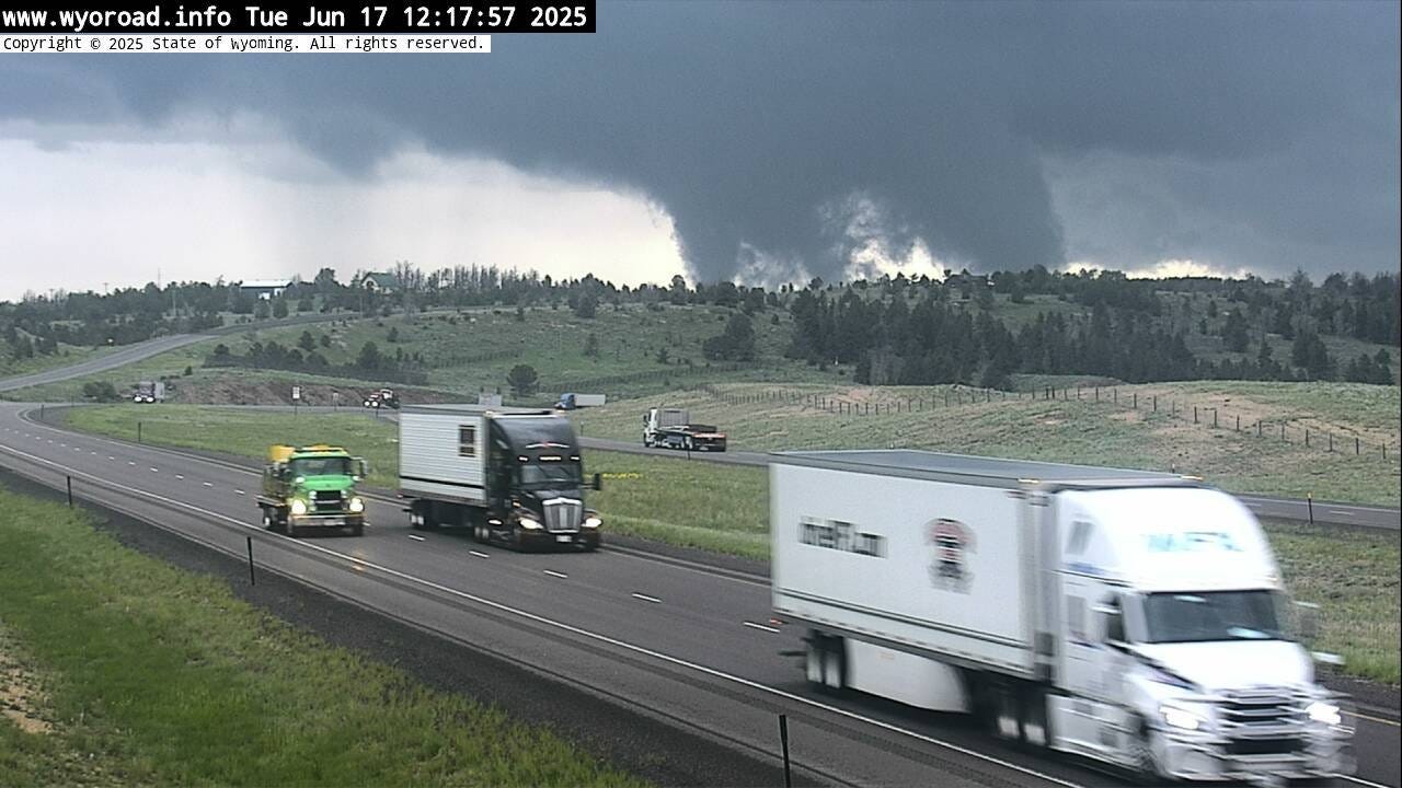
Officials working to categorize Tuesday’s ‘unusual’ tornado
Touching down around Dymek Hill, the funnel was the result of one storm crashing into another. No one was hurt.

A tornado touched down a few miles east of Laramie Tuesday, while hail up to two inches in diameter pelted the eastern edge of town.
Michael Natoli, a meteorologist with the National Weather Service in Cheyenne, said the mechanism that created the tornado was rare for the region.
“This was kind of a more typical event of the Midwest area of the United States, in that we had a line of storms, and this tornado was kind of a quick spin-up along the line,” he said. “There was a storm that developed ahead of the main line of storms on the east side of Laramie, and then a much faster moving storm was coming in from the west.”
That faster storm caught up to the slower-going initial storm and “created a brief period of favorable rotation that was able to get a quick spin-up,” Natoli said.
The crash of storms created rotation and the rotation became a tornado when it touched the ground. The tornado lasted an estimated five minutes, from about 12:25-12:30 p.m.


Natoli said tornados are rare but not uncommon in Wyoming, with the Laramie Valley experiencing at least a small one every few years. But the way Tuesday’s tornado formed, from a line of storms, set it apart from others.
“Usually, tornadoes here are either landspouts or supercell thunderstorms,” Natoli said. “This is what we call a quasi-linear convective system, or QLCS, which is pretty rare in Wyoming, but much, much more common as you head east, kind of in the Midwest. So it was an interesting event to be here for sure.”
The tornado’s strength has yet to be verified but officials say it was likely weak. The first damage reports, of trees near Dymek Hill on Medicine Bow National Forest land, arrived Wednesday afternoon. NWS hopes to place the weather event on the EF scale by Friday.
The EF scale is used to estimate wind speeds in a tornado by assessing the damage caused. Until NWS and Albany County Emergency Management had gathered damage reports, no estimation could be made, and the tornado appeared slated to go down in history as an EFU, the “U” standing for “unknown” while standing in for a number between 0-5.
(Not) hearing the sirens call
Social media was abuzz Tuesday, as Laramie residents caught glimpses of the storm from town, or else stumbled across Emergency Management’s tornado warning on Facebook.
But ACEM Coordinator Kate Allred said Laramie itself was never threatened, which is why the in-town sirens never sounded. The sirens — officially known as the Outdoor Warning System — are set to be automatically triggered when the National Weather Service issues a tornado warning for their area of coverage.
Given that the tornado was spotted several miles east of town, no warning was issued for Laramie and the sirens did not sound.
“The Outdoor Warning System was not activated for the tornado yesterday due to there being no threat to the City of Laramie as it was reported by the National Weather Service as being approximately eight miles from the City of Laramie heading Northeast, away from populated areas,” Allred said. “Had the tornado been traveling in the opposite direction, or located closer to the City or an area where there was a siren, they would have been activated immediately.”
The siren is a good way to know if there’s a threat to your area, Allred said.
“If you hear an emergency siren wail, and it is not during our monthly tests on the first Friday of every month at 10 a.m., then a tornado has likely been confirmed in the area and you should seek shelter immediately,” she said.
Residents can also sign up for Albany County Alerts, to receive information about tornados and other threats.
Hot weekend ahead
The storms appear to be finished for now.
“It looks like we’re going to be very warm and dry — pretty much very little to no chance for thunderstorms through at least Saturday,” Natoli said. “And we are also going to be seeing some very hot temperatures coming in over the next few days. We may be pushing daily record highs in Laramie on Friday and Saturday.”
The hottest June 20 on record, in 2017, was 88 degrees. NWS says Friday could hit 89 degrees.
The hottest June 21 on record, in 2016, was 91 degrees. NWS says Saturday could hit 88 degrees — three degrees short of the record, but within range of history-setting temps if conditions change.
The first Laramie Farmers Market of the summer is scheduled for Friday, from 4-8 p.m.
“We’ll be very close to, if not slightly above, the daily record highs,” Natoli said. “The all-time record high for Laramie is 94 degrees, and that was set numerous times.”
Laramie is expected to see significantly more very hot days per year, on average, due to climate change warming the planet.
Despite the dry days ahead, Laramie is ahead of schedule this year for precipitation.
“Since January 1, Laramie has picked up 5.76 inches of rain,” Natoli said. “And the normal to-date, as of June 17, is 4.82 inches. So we’re almost an inch above average for the year as a whole.”